
Why is the Basin Round? The Michigan Basin Supervolcano Hypothesis
- Feb 16
- 5 min read

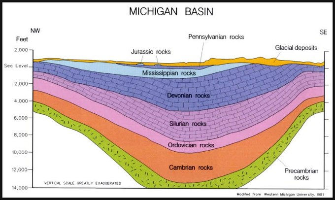
The Michigan Basin is a bowl shape underneath the mitten of Michigan. It is thought to have been formed by the successive layers being pushed downward. But we think it obvious that there was a very large super volcano, about 2 Billion years ago, along what is called the Midcontinent Rift. This crater then collapsed, to be filled in by the Cambrian and layers following. The Porcupine Mountains and the belt of copper around the Keweenaw Peninsula follow the circumference of the Basin, and these mountains are among the oldest in the world, estimated at 2 Billion years old. The three Great Lakes- Michigan Huron and Erie, are within the Basin, while the deepest lakes, Superior and Ontario, are outside the Basin along the Rift, which seems to have nearly left Canada with Europe when the continents separated throughout the following billions of years. There is a Super volcano at Yellowstone, which last erupted about 640 thousand, that is, less than ONE million years ago years ago, and it is evident from previous eruptions near Yellowstone to the West SW that the crust of the earth has moved from the shaft. What we say is that something similar obviously occurred along the Midcontinent Rift at least as long ago as the Porcupine Mountains were formed
The rings of Michigan bedrock are due to sediments deposited in each of the past geological ages. These filled in the basin, then the softer rock was scoured out by glaciers. In the moraines of South eastern Michigan, we find brachiopods, “winged clams,” we call them, from the Devonian period of about 350-400 million years ago, but little that is more recent, and no Dinosaur bones as are found in the west and Southwest United States.
Here is the Midcontinent Rift:


Here is the basin when salt was being deposited

The Porcupines are OLD mountains! The mystery of the Michigan Basin deepens: Wikipedia The Porcupine Mountains:
:

These mountains and the copper belt are in the outer layer of the basin, following the circumference, It could still be a meteor, if this disturbed the crust 2 Billion years ago…
The hypothesis is that The Porcupine Mountains and Michigan copper are from the volcano that made the Michigan basin, 2 Billion years ago.
The Yellowstone super volcano last went off about 640,000 years ago- more recent than ONE million years, whereas the Michigan basin volcano would be 2 Billion years ago, about 3 thousand times as old, just after earth was cooling and the land appearing. Similar to the Michigan Basin, Yellowstone did not leave a mountain, and we figured out with some difficulty and quite recently that the Yellowstone super volcano was there at all. Joe Boyd in the 1950’s figured that one out.

It is said that the basin is Geologically passive, but it is odd that there just happens to be Precambrian mountains and volcanic stuff shaped like the edge of the basin at the Porcupine Mountains. The current best guess is stated on Wikipedia is as follows: “The basin appears to have subsided concurrently with sediment infilling. These sediments were found to be mainly shallow-water sediments, many of which are richly fossiliferous. The location was on a geologically passive portion of crust.” Guess again! But here we see the subduction causing the Basin and the Porcupines may have been later than the huge eruption.
In The Lake Superior Basin’s Fiery Beginning https://www.lakesuperior.com/the-lake/natural-world/243-lake-superior-basin-fiery-beginning/, John C. Green writes:
“In our area, the oldest rocks are about 2.7 billion years old. Found mostly along Lake Superior’s Ontario shores and located in the area called the Superior Province of the Canadian Shield, these ancient rocks date from the Archean Eon.”The volcanic and granitic rocks tell us of the building of great mountain ranges, perhaps rivaling the Alps but which have since been eroded to the nub. The rocks we see today along the lakeshore in Ontario were once miles beneath the surface, exposed after hundreds of millions of years of erosion removed the overlying rocks.”
“Instead of lava dribbling and drooling down the flanks of large volcanic mountains, imagine huge fountains of intensely glowing lava spurting up from fissures that extended for miles across a barren plain. So much highly fluid lava would erupt in one event that it simply spread out, in many cases for hundreds, or even thousands of square miles, to form a huge, pancake-like lava flow.”
Called a “plume,” this rising cylinder of hot mantle rock came up and spread out under the stiffer lithosphere (the crust and uppermost mantle). This plume (as illustrated on the bottom of this page) apparently centered under where Lake Superior is today and, in fact, determined where our Great Lakes would eventually develop.”

One Geologist comments that the location of the Michigan Basin “was on a geologically passive portion of crust. The development of the basin and the surrounding arches were likely affected by the tectonic activity of the long-term Appalachian orogeny several hundred miles to the south and east.”
The continents were all together then- New York matches up with Scotland, the lower East coast with Africa. Somewhere in there is where the 3 continents came together- around the Pillars of Hercules.
The official Michigan website states: “The 2 billion year old Porcupine Mountains themselves arise abruptly from Lake Superior to form a 12 mile long escarpment which parallels the lakeshore for a distance of 1.5 miles.” At 2 billion years old, the mountains are a section of one of the oldest mountain chains in the world. (Michigan.Gov, Porcupine Mountains). The 5 Oldest Mountain Ranges are: The Barbertown Greenstone Belt (3.6 Billion Years); South Africa and Swaziland; The Hamersley Range (3.4 Billion Years); The Waterberg Mountains (2.7 Billion Years); The Magaliesberg (2.3 Billion Years); Guiana Highlands 2 billion years ago.
I’m guessing the Basin was caused by a super volcano around 2 Billion years ago. In History of the Earth: Michigan Basin https://historyoftheearthcalendar.blogspot.com/2014/03/march-12-michigan-basin.html?spref=tw… This author, Richard I Gibson, notes that the layers are thicker in the center. This would seem to mean the center was lower when the layers were deposited, rather than subducting as the layers were formed.
All that is required for the super volcano hypothesis is that the huge plume of which Green writes came out right under the Michigan basin, causing a circular collapse of the column.
This is where the ocean was when the salt was being deposited in the basin about 400 million years ago:

The layers at the Grand Canyon:

These show what was going on during the depositing of each layer, and the vertical layers that would occur if not for the basin. The glaciers have scoured away most of the post Jurassic- so we have few dinosaur bones, though an occasional mammoth from after glacier times. Scoured away and we were repeatedly under water, since the Pennsylvanian


I
n some 12,000 years, it is said Niagra falls, receding, will arrive at Lake Erie, and the lakes suddenly drain to that level. Buy lakefront property! We could sell water to Colorado in 11 thousand years, as this would soon be lost.
Before the continents even separated, we almost left the Canucks with Europe!
Comments